Toronto Island
Map of: Toronto Island — Plan of the subdivision of "The Eastern Point", 1880
By: Unknown
Image courtesy of Toronto Public Library. Source.
Google Maps modern view
Map of: Toronto Island, plan of park improvement and proposed water ways to accompany a report of commissioner of parks, dated Dec. 15th, 1903.
By: Villiers Sankey
Signed by Villiers Sankey, City Surveyor and by John Chambers, Commissioner of Parks.
Published by: Rolph and Clarke
Image courtesy of Toronto Public Library. Source.
Google Maps modern view
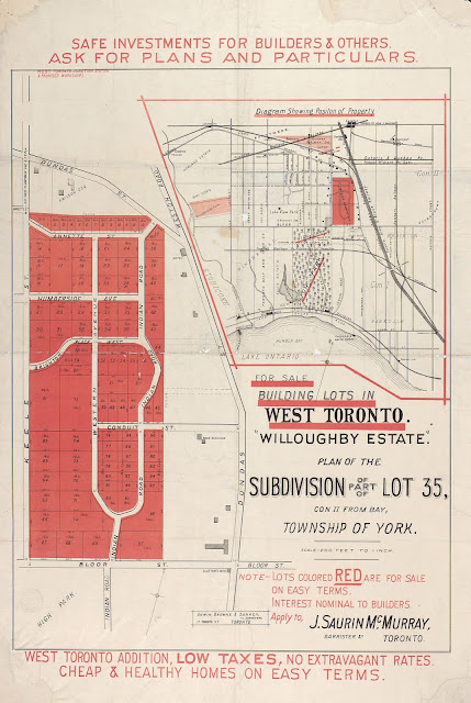
High Park
Map of: "Willoughby estate"; plan of the subdivision of part of lot 35, con. II from bay, township of York. 1880.
By: Unwin, Browne & Sankey, Toronto
West Bend neighbourhood, Toronto.
Image courtesy of Toronto Public Library. Source.
Google Maps modern view
Pape Village (Broadview North)—Uptown Park: Pape and Sammon
Map of: Upton Park, 1925(?)
By: The Pape Avenue Land Company Ltd.
Image courtesy of Toronto Public Library. Source.
Google Maps modern view.
I can't quite decide whether this is in 'Old East York', 'Broadview North', or 'Pape Village'.
The cover of the Uptown Park marketing brochure:
Yorkville (plus Seaton Village and Rosedale)
Map of the village of Yorkville and vicinity, compiled from plans & filed in the Registry Office and shewing subdivisions in lots 16 to 28 in the second concession from the bay in the township of York, 1877
By: Silias James
Image courtesy of Toronto Public Library. Source.
Google Maps modern view
It’s interesting that the ‘vicinity’ of Yorkville apparently extends from Seaton Village out to Rosedale.
Map of Yorkville and its vicinity, 1878
By: Alfred T. Cotterell (pub: Ralph Smith & Co.)
From: 1878 Illustrated Historical Atlas of the County of York
Image courtesy of Toronto Public Library. Source.
Google Maps modern view
Note the City Reservoir.
Etobicoke
Map of the township of Etobicoke, in the county of York, compiled by Charles Unwin, Provincial Land Surveyor, Provincial Chambers, Toronto. 1856.
By: Charles Unwin
Image courtesy of Toronto Public Library. Source.
Google Maps modern view.
Weston Village - Denison Estate
Map of: Denison Estate (Village of Weston), plan of the subdivision of part of lots 3 and 4, 5th con west of Yonge St., 1875
By: >[ Signature ]: A.D.
The plan was donated to the library with the Denison family papers in 1989.
Image courtesy of Toronto Public Library. Source.
Google Maps modern view.
Note: St. John's Cemetery
Lawrence Park Estates And Southern Addition Strathgowan
Map of: Lawrence Park Estates And Southern Addition Strathgowan, 1910.
by: Dovercourt Land Building & Savings Company Limited
Image courtesy Toronto Public Library. Source.
Modern view via Google Maps.
Lawrence Park Estates Birds Eye View.
See also this brochure, "Lawrence Park Estates : a formal & artistic grouping of ideal homes" on the new subdivision.


